
Sixty-five million years ago, two large ancient continents gradually approached each other, which were north and south in the middle of the period, which will be named the third period later by geologists, and the clash was inevitable at the end. After this clash, Anatolia, which lies between the two continents, began to be pressed down. Thus, the two mountain ranges, which are named Toroslar in Anatolia today, rose to the north and south of Turkey. This uplift continued until it reached 4000m above sea level.
As a result of this process, the earth’s crust cracked at many points. Diffraction points which resulted in magma rising from the depths of the earth to the surface. Geologists call these points, where the magma rises to the face of the earth, volcanoes. This is why Turkey is full of volcanoes. There are three major volcanoes in the region, which historians will later name Cappadocia. Archaeologists later managed to reach some conclusions on this subject. Among these was a wall painting discovered 9,000 years old showing the mountain of Hasan with erupting lava. This find came from Catalhoyuk, a Neolithic settlement 200 km from Cappadocia. These three mountains were later called Hasan Mountain, Erciyes Mountain and Melendiz Mountain by the people who lived there.
Cappadocia owes its beauty to these three volcanoes. The lava that gushed out of these mountains accumulated in the region for a very long time. People later discovered that among the solid things that gushed out of the volcano, the ash had a different importance. The ash ended up covering a very large area due to the effect of the wind and formed a deep layer. This layer, which later became hard and turned into a stone, can be easily worked even by hand. People gave the stones the name tuff limestone. Today, the tuff layer in the Cappadocia region changes from region to region and can be up to 100m thick. Whether in the world or in Turkey, there are many volcanoes, but Cappadocia is unique. The main reason for this is the activity of the three volcanoes, which resulted in the accumulation of a thick layer of tuff in the region by spewing lava all at the same time.
If the tuff layer was thin, it would disappear over time due to erosion and there would be no beauty at all. Volcanic activity in the region ended at the beginning of the period, which geologists call the Fourth Period. After this date, a new period began in the region. This new period was defined as the corrosion period. The period of corrosion that began as a result of the activity of wind, rain and natural effects created obvious effects over time. The soil, affected by the corrosion, and the hardest blocks that could resist this corrosion showed interesting aspects and formations. These formations could not be interpreted by the people who lived here later and it was decided that the spirits could make them. Because of this, even today, these formations are called “fairy chimneys”.
If small pieces of rock on top of large rocks, the transformation of tuff layers into the shape of valleys and gorges are not divine pictures painted on a natural canvas, then what are they?
Pasabag
The fairy chimneys of Pasabag, on the road from Goreme to Avanos, offer a unique view for visitors. They resemble monks and some have peculiar bodies or seem to have more than one head! St. Simon had resided in one of them in order to avoid the people of Jerusalem who were disturbing him once news of his miracles had spread. St. Simon arrived there in the 5th century AD, and he stayed in a fairy chimney that had three heads and consisted of two rooms. It can be reached via steep stairs. In addition to St. Simon, a number of monks made use of the fairy chimneys as an area of seclusion and offered them peace, and Pasabag was also known as the Valley of the Monks.
Zelve
This is one of the most famous rock chimney villages in the Cappadocia region, created by volcanic tufa. Zelve was inhabited until the mid-20th century, but its population moved to Yeni Zalve for fear of a rock collapse, and the old village was turned into an open-air museum. Three canyons intersect at the entrance to the museum. The first one (on the right) is accessed through the Church of the Deer (Ceyikli Kilise) where you can see paintings including a cross, a deer and a fish. It is important to mention that fish were often used in Cappadocia’s churches as a religious symbol. The section on the left leads to another church, which has been converted into a mosque. At the end of this gorge, there are two stone facades that look like honeycombs, in which there are caves, dovecotes and other rooms. There are also tunnels there, allowing access to the third gorge.
The Church of the Grapes (Uzumlu Kilise) is located in the third gorge. The grape juice seen there symbolizes the blood of Jesus Christ.
Urgup
The town of Urgup is located in the center of Cappadocia, 23 km from Nevsehir. The Tekke and Topuz mountains surround it from the east and the Avla and Germil mountains lie to the south. The city was named after the Hittite word kup Ur, which means “many castles”. It’s important to know that St. Paul passed through Urgup during one of his trips to Anatolia. The city was first explored by the Frenchman Paul Lucas, who described it as “the fantastic cemetery of an extinct civilization. ” However, later other explorers examined the dwellings that had been carved out of the rocks. They discovered churches and typical Cappadocian houses carved into the rock. Pieces of Selcuk and Ottoman art can be seen in Urgup. You can visit the tombs of Altikapi and Nukreddin, the underground passage, the Archaeology and Ethnography museums and the Aga Tahir Library.
The modern city of Urgup is a popular destination for people visiting Cappadocia, thanks to its nightlife and other tourist sites.
Heading south, 5 km from Ugrup, there is another town known as Mustafapasa, whose former name was Sinassos. There are houses with beautiful stone walls, an expression of 19th century art, and the churches of St. Apostles, St. Basil and Tavsanli. There is another small town called Ortahisar, 1 km from Urgup, on the highway from Kayseri to Nevsehir, where you can see old monasteries and churches, as well as a castle carved out of the rock, where Christians and Muslims used to turn to in order to escape the Mongols.
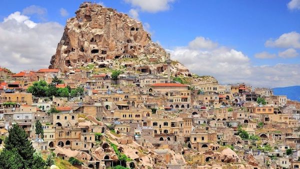
A small town on the road from Nevsehir to Urgup is known as Uchisar and is located at the highest point of the valley. The town was named after its castle which was built on a huge rock. It is possible that the town’s strategically important position on the Silk Road led the Hittites to build this castle
0 Comment